

.
Severe
Weather And Clouds

Clouds That
Spell Severe Weather
by Tiffany Means
Shady Clouds
 When
the threat of severe weather looms, clouds are often the first sign that skies
are turning unfriendly.
When
the threat of severe weather looms, clouds are often the first sign that skies
are turning unfriendly.
Look for the
following types of clouds during disturbed weather; recognizing them and
the severe weather they're linked to could give you a head start to finding
shelter!
Cumulonimbus

They develop from convention --
the transport of heat and moisture upward into the atmosphere.
But, whereas other clouds
form when air currents rise several thousand feet and then condense where
those currents stop, the convective air currents that create cumulonimbus are
so powerful, their air rises tens of thousands of feet, condensing
rapidly, and often while still journeying upward.
The result is a
cloud tower with bulging upper portions (that look something like
cauliflower).
If
you see a cumulonimbus, you can be sure there's a nearby threat of severe
weather, including bursts of rainfall, hail, and possibly even
tornadoes.
Generally, the taller the
cumulonimbus cloud, the more severe the storm will be.
Anvil Clouds
 An
anvil cloud isn't a stand-alone cloud, but more of a feature that
forms at the top of a cumulonimbus cloud.
An
anvil cloud isn't a stand-alone cloud, but more of a feature that
forms at the top of a cumulonimbus cloud.
The
anvil top of a cumulonimbus cloud is actually caused by it hitting the top of
the stratosphere -- the second layer of the atmosphere.
Since this layer acts as a
"cap" to convection (the cooler temperatures at its top discourage
thunderstorms), the tops of storm clouds have nowhere to go but outward.
Strong winds high up fan this
cloud moisture (so high up that it takes the form of ice particles) out over
great distances, which is why anvils can extend outward for hundreds of miles from
the parent storm cloud!
Mammatus

Whoever
first exclaimed "The sky is falling!"
must have seen mammatus clouds overhead.
Mammatus appear as
bubble-like pouches that hang on the underside of clouds.
As odd as they look, mammatus
aren't dangerous -- they simply signal that a storm may be nearby.
When
seen in association with thunderstorm clouds, they're typically found on the
underside of anvils.
Wall Clouds
It takes it's name from the
fact that it resembles a dark gray wall (sometimes rotating) that lowers
down from the base of the parent storm cloud, usually just before a tornado is
about to form.
In other words, it is
the cloud from which a tornado spins.
Wall
clouds form as the thunderstorm updraft draws in air near the ground from
several miles around, including from the nearby rain shaft.
This rain-cooled air is very
humid and the moisture within it quickly condenses below the rain-free base to
create the wall cloud.
Shelf Clouds
 Like
wall clouds, shelf clouds also form underneath thunderstorm clouds.
Like
wall clouds, shelf clouds also form underneath thunderstorm clouds.
As you can imagine, this
fact doesn't help observers differentiate between the two.
While one is easily mistaken
for the other to the untrained eye, cloud spotters know that a shelf cloud is
associated with thunderstorm outflow (not inflow like wall clouds) and can be
found in the storm's precipitation area (not rain-free area like walls
clouds).
Another
hack to telling a shelf cloud and wall cloud apart is to think of rain
"sitting" on the shelf and a tornado funnel "coming down"
from the wall.
Funnel Clouds
Produced when a rotating
column of air condenses, funnel clouds are the visible part of tornadoes that
extend downward from the parent thunderstorm cloud.
But
remember, not until the funnel reaches the ground or "touches down"
is it called a tornado!
Scud Clouds
 Scud
clouds aren't dangerous clouds in and of themselves, but because they form
when warm air from outside of a thunderstorm is lifted up by its
updraft, seeing scud clouds is a good indication that a cumulonimbus cloud (and
hence, a thunderstorm) is nearby.
Scud
clouds aren't dangerous clouds in and of themselves, but because they form
when warm air from outside of a thunderstorm is lifted up by its
updraft, seeing scud clouds is a good indication that a cumulonimbus cloud (and
hence, a thunderstorm) is nearby.
Their
low height above ground, ragged appearance, and presence beneath cumulonimbus
and nimbostratus clouds mean scud clouds are often mistaken for funnel clouds.
But there's one way
to tell the two apart -- look for rotation.
Scud do move when caught in
the outflow (downdraft) or inflow (updraft) regions but that motion typically
isn't rotation.
Roll Clouds
 Roll
or arcus clouds
are tube-shaped clouds that literally look like they've been rolled up into a
horizontal band across the sky.
Roll
or arcus clouds
are tube-shaped clouds that literally look like they've been rolled up into a
horizontal band across the sky.
They appear low in the sky
and are one of the few severe weather clouds that are actually detached from
the storm cloud base. (This is one trick for telling them apart from shelf
clouds.)
Spotting one is rare, but
will tell you where a thunderstorm's gust front or other weather boundary, like
cold fronts or sea breezes lay, since these clouds are formed by
outflows of cold air.
Those
in aviation may recognize roll clouds by another name - Morning Glorys.
Wave Clouds

Wave,
or Kelvin-Helmholtz clouds, resemble breaking ocean waves in the sky.
Wave clouds are created when
air is stable and winds at the top of a cloud layer are moving faster
across it than those below it, causing the top clouds to be whipped around
in a downward curling motion after hitting the stable layer of air above.
While
wave clouds aren't related to storms, they are a visual cue for
aviators that a large amount of vertical wind shear and turbulence are in the
area.
Asperitas Clouds
 Asperitas are
another cloud type that resemble a roughened sea surface.
Asperitas are
another cloud type that resemble a roughened sea surface.
They appear as if you
were underwater looking upward toward the surface when the sea is particularly
roughened and chaotic.
Although
they look like dark and storm-like doomsday clouds, asperitas tend to develop after convective
thunderstorm activity has developed.
Much is still unknown about
this cloud type, as it is the newest species to be added to the World
Meteorological Organization's International Cloud Atlas in over 50
years.
 Spotting Clouds That Could Mean Danger

Now that you know which clouds are related
to severe weather and what they look like, you're one step closer to becoming a
storm spotter!
Tiffany
Means is a meteorologist, science writer,
and avid cloud watcher/photographer.
Experience
Tiffany
has been finding beauty skyward and sharing it with others since the age of 5.
By twelve, she knew she wanted to pursue weather professionally—thanks in part
to the release of the blockbuster film Twister. Since those days, Tiffany has interned with the domestic and
international weather departments at CNN, written monthly climate reports for
NOAA’s National Centers for Environmental
Prediction, and participated in a number of science outreach events
(such as the Science Olympiad Competition). She has personally experienced
such weather greats as the Blizzard of 1993, and
the floods of Hurricane Francis (2004) and Ivan (2004).
Education
Tiffany
holds a bachelor’s degree in Atmospheric Science with a concentration in
weather forecasting from the University of North Carolina at Asheville.
Tiffany
is a proud member of the American Meteorological Society (AMS).
Tiffany Means
"Weather
affects us all. We check it on a daily basis, and talk about it with
complete strangers...but it is so much more than 5-day forecasts and small
talk! Through my enthusiasm for and expertise in the weather sciences, I hope
to spark your curiosity about our atmosphere, create an awareness that will
keep you weather ready and safe, and strengthen your environmental
responsibility to our atmosphere, water, and earth."
Contact
Tiffany: Tiffany can be reached at aboutweatherexpert@gmail.com with questions,
comments, reprint requests, or suggestions. You can also connect with her via
the social links below.
.
 |
| Multi-Media Filter, Highly-Activated Carbon Filter, Zeolite-Process Water Softener With Brine Tank, Fiberglass Ballast-Type Pressure Tank (fully automatic backwash & regeneration) |
.
PURICARE
Treatment
Systems
.
...
Aganan, Pavia, Iloilo, Philippines
Aganan, Pavia, Iloilo, Philippines
...
CLICK HERE . . . to view company profile . . .
CLICK HERE . . . to view company profile . . .
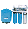 | ||
| Reverse Osmosis with Steel Tank & Cartridge Pre-Filters
|


 |
| Tachmina Solenoid-Driven Chemical Metering Pump - ensures regulated dosing of chlorine into water system without human intervention |


No comments:
Post a Comment