Showing posts with label Waves. Show all posts

Tuesday, January 19, 2021

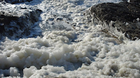
SEA FOAM - Sea foam is created by the agitation of seawater containing high concentrations of dissolved organic matter, which can come from the natural environment in the form of algal blooms or from man-made sources. As the waves crash onto the shore or lap at the beach, depending on where you are, there's usually some leftover frothy bits that cling to the sand. On windy days, this foamy stuff can even be lifted off the ground and blown around. What is it? And is it dangerous to touch it or let the dog run around in it? It's sea foam, and it is not nearly as green as the color we call sea foam. It's usually whitish, though it's probably a little dingy rather than being sparkling white. Sometimes it's more of a reddish-brown, though, and that's the sea foam to watch out for. Sea water is 96.5 percent water and 2.5 percent salt. That only adds up to 99 percent, so what's the other 1 percent? A lot of things - it's "proteins, fats, dead algae, detergents and other pollutants," plus other bits of organic and inorganic matter. When these particles get agitated by wind and waves, they froth. You can create the same effect by putting some sea water in a bottle and shaking it. The bubbles happen because of molecules called surfactants. These surfactants can come from natural sources, like algae and seaweed, or from human pollution, like fertilizers, detergents and sewage. One end of the molecule is hydrophobic – it repels water. The other end is hydrophilic – it attracts water.

.......................................................................................................................................................................................................................................................................................................................................................................................................

What Exactly Is Sea Foam?

BY KRISTEN HALL-GEISLER


Sea foam is created by the agitation of seawater containing high concentrations of dissolved organic matter, which can come from the natural environment in the form of algal blooms or from man-made sources. 

As the waves crash onto the shore or lap at the beach, depending on where you are, there's usually some leftover frothy bits that cling to the sand.

On windy days, this foamy stuff can even be lifted off the ground and blown around.

What is it? And is it dangerous to touch it or let the dog run around in it?

It's sea foam, and it is not nearly as green as the color we call sea foam. It's usually whitish, though it's probably a little dingy rather than being sparkling white.

Sometimes it's more of a reddish-brown, though, and that's the sea foam to watch out for.

Sea water is 96.5 percent water and 2.5 percent salt. That only adds up to 99 percent, so what's the other 1 percent?

A lot of things. According to the National Oceanic and Atmospheric Administration (NOAA), it's "proteins, fats, dead algae, detergents and other pollutants," plus other bits of organic and inorganic matter.

When these particles get agitated by wind and waves, they froth. You can create the same effect by putting some sea water in a bottle and shaking it.

The bubbles happen because of molecules called surfactants, which Popular Science explains are "sticky molecules that cling to the surface between water and air."

These surfactants can come from natural sources, like algae and seaweed, or from human pollution, like fertilizers, detergents and sewage.

One end of the molecule is hydrophobic – it repels water. The other end is hydrophilic – it attracts water.

The easiest shape for these molecules to form is a sphere, with the hydrophobic ends on the inside and the hydrophilic ends pointing outward.

Spheres (even if they aren't perfect) make bubbles. And a lot of bubbles make sea foam!

Now, about that reddish-brown sea foam. That's often due to phytoplankton, also known as algae blooms, which is a natural phenomenon.

These tiny organisms release toxins that aren't good for you, your dog, the birds, or anything, really. The toxins can irritate eyes and ears, and even the respiratory system.

The white foam may not be toxic, but that doesn't mean it's harmless.

When weather gets completely out of control, the churning of the water creates a lot of sea foam.

Like, a lot. In the winter of 2020, a king tide in Washington state with 25-foot (nearly 8-meter) waves created a "blender effect" that churned up sea foam as high as a man's chest.

Later that spring and halfway around the world, so much sea foam appeared in the Netherlands that it killed five very experienced surfers.

NOW THAT'S COLOR

In 2001, Crayola introduced a minty-green crayon called "seafoam."

According to Canva, it's a soft blue-green that is not the same as mint green. These two colors have different hex codes used by designers.

Seafoam is a mix of green, blue and a little gray, and it looks nothing like the sea foam found in the actual sea.

Kristen Hall-Geisler

CONTRIBUTING WRITER

Kristen Hall-Geisler is a freelance writer and book editor living in Oregon. As an automotive journalist since 2006, she's honed her research and interviewing skills with HowStuffWorks, The New York Times, TechCrunch, Popular Science, US News & World Report and more. She loves falling down the rabbit hole of research and emerging with a book or article that others find useful and — she hopes — entertaining while still being based on solid sources. She is the author of the historical novel "Skull and Sidecar" as well as the nonfiction books "Take the Wheel: A Woman’s Guide to Buying a Car Her Own Damn Self" and "Lightning in a Throttle: Three Early Electric Vehicle Victories."

https://science.howstuffworks.com/environmental/earth/oceanography/sea-foam.htm?utm_medium=recirc&utm_source=taboola&utm_campaign=feed


You might also like:


Algae Blooms 

(Red Tides)

CLICK HERE . . . to view . . . 

https://puricare.blogspot.com/2017/07/algae-blooms-red-tides-algae-blooms-are.html

...........................................................................................................................................................................................................................................................................................

Detergents And Water Pollution

CLICK HERE . . . to view . . . 

https://puricare.blogspot.com/2017/07/detergents-and-water-pollution-many-of.html

...........................................................................................................................................................................................................................................................................................

A dangerous guide to beachcombing

CLICK HERE . . . to view . . . 

https://puricarechronicles.blogspot.com/2017/12/beachcombing-if-you-see-something-that.html

...........................................................................................................................................................................................................................................................................................

Water Contaminants 

CLICK HERE . . . to view . . . 

https://puricare.blogspot.com/2016/10/water-contaminants-health-effects-epas.html

...........................................................................................................................................................................................................................................................................................

Foam Definition in Chemistry

CLICK HERE . . . to view . . . 

https://puricare.blogspot.com/2019/10/foam-definition-foam-is-substance-made.html

...........................................................................................................................................................................................................................................................................................

The Dead Sea & Bible Prophecy

CLICK HERE . . . to view . . . 

https://puricarechronicles.blogspot.com/2020/05/the-dead-sea-bible-prophecy-ezekiels.html

...........................................................................................................................................................................................................................................................................................

Worsening Algal Blooms

CLICK HERE . . . to view . . . 

https://puricare.blogspot.com/2020/05/worsening-algal-blooms-toxic-algae.html

Monday, December 21, 2020

THE MAKING OF A SUPER STORM - Sandy started out as a classic hurricane, getting energy from the warm waters of the Caribbean and moving northward along the Gulf Stream. Sandy then took a sharp left turn into the New Jersey and New York coasts and collided with a winter-like storm system.As Sandy’s energy source transitioned from the warm ocean water to the atmosphere it morphed into a wintertime cyclone and dramatically increased in size. For seven days in the Fall of 2012, Hurricane Sandy pounded the Caribbean and US East Coast with punishing rain, wind, and waves. As the storm approached landfall, the National Hurricane Center renamed the hurricane "Post-Tropical Cyclone Sandy." But to those whose lives were devastated – it will always be remembered as super storm Sandy. What happened in the atmosphere that caused this monstrous storm to form? Summer and winter weather conditions collided with extreme forces. The primary difference between a tropical cyclone, also called a hurricane, and a wintertime cyclone is the energy source. Tropical cyclones extract heat from the ocean and grow by releasing that heat in the atmosphere near the storm center. Wintertime storms, on the other hand, get most of their energy from temperature contrasts in the atmosphere, and this energy usually gets distributed over larger areas.Sandy started out as a classic hurricane, getting energy from the warm waters of the Caribbean and moving northward along the Gulf Stream. Sandy then took a sharp left turn into the New Jersey and New York coasts and collided with a winter-like storm system.

.............................................................................................................................................................................................................................................................................................................................................................................................................

The Making of a Super Storm

Sandy is a heartbreaking reminder that the end of summer isn’t the end of hurricane season.

.

Sandy started out as a classic hurricane, getting energy from the warm waters of the Caribbean and moving northward along the Gulf Stream. Sandy then took a sharp left turn into the New Jersey and New York coasts and collided with a winter-like storm system. As Sandy’s energy source transitioned from the warm ocean water to the atmosphere it morphed into a wintertime cyclone and dramatically increased in size.

Ocean Today


For seven days in the Fall of 2012, Hurricane Sandy pounded the Caribbean and US East Coast with punishing rain, wind, and waves.

As the storm approached landfall, the National Hurricane Center renamed the hurricane "Post-Tropical Cyclone Sandy."

But to those whose lives were devastated – it will always be remembered as super storm Sandy.

What happened in the atmosphere that caused this monstrous storm to form?

Summer and winter weather conditions collided with extreme forces.

The primary difference between a tropical cyclone, also called a hurricane, and a wintertime cyclone is the energy source.

Tropical cyclones extract heat from the ocean and grow by releasing that heat in the atmosphere near the storm center.

Wintertime storms, on the other hand, get most of their energy from temperature contrasts in the atmosphere, and this energy usually gets distributed over larger areas.

Sandy started out as a classic hurricane, getting energy from the warm waters of the Caribbean and moving northward along the Gulf Stream.

Sandy then took a sharp left turn into the New Jersey and New York coasts and collided with a winter-like storm system.

As Sandy’s energy source transitioned from the warm ocean water to the atmosphere it morphed into a wintertime cyclone and dramatically increased in size.

High winds extended 1,000 miles across bringing record-breaking storm surges to coastal areas and blizzard conditions to the mountains.

Tunnels turned into rivers and parking lots into ponds.

Residents returned to find their belongings floating in pools of water in their homes and yards.

Cars were pushed around like toys and mountains of sands filled the streets.

Power outages lasted for days, weeks, and in some places for months. One neighborhood even burned to the ground.

Initial calculations for damages were $50 billion.

As cities and towns rebuild that number continues to rise.

Sandy is a heartbreaking reminder that the end of summer isn’t the end of hurricane season.

Hurricane season runs from June 1 to November 30 with the peak of the season from mid-August to late October.

Put together an emergency plan and supply kit now, so you are prepared for extreme weather no matter when it strikes.

Fast Facts

Sandy, as a hurricane and a post-tropical cyclone, killed at least 117 people in the United States and 69 more in Canada and the Caribbean.

Sandy ranks as the second-costliest storm on record at $68 billion. Hurricane Katrina of 2005 is the highest at $108 billion.

The New York Stock Exchange closed for two consecutive days, the first time this has happened because of weather since 1888.

At its peak intensity, Hurricane Sandy measured a Category 3 as it made landfall in Cuba.

Sandy was the 18th named storm, 10th hurricane, and second major hurricane of 2012.

The Ocean Today website provides access to the current and archived videos that play on the Ocean Today multimedia exhibit. Ocean Today was designed as a highly dynamic, visitor-friendly experience at the Sant Ocean Hall in the Smithsonian Institution's National Museum of Natural History. It has expanded to many other locations around the world.

The Ocean Today website is an online archive of the videos that appear on the physical kiosks. The videos are categorized in the seven theme areas: Collections, Danger Zone, Exploration, Fix the Ocean, Go Fish, Marine Life, and Research. A description of Ocean Today, kiosks locations, how to obtain a kiosk and requirements, and contributor information can found in the “What is Ocean Today” section.

https://oceantoday.noaa.gov/makingofasuperstorm/


You might also like:


Weather Signs of an Incoming Storm

https://puricare.blogspot.com/2020/10/weather-signs-of-incoming-storm-how-to.html

...........................................................................................................................................................................................................................................................................................

Storm Surge

CLICK HERE . . . to view . . . 

https://puricare.blogspot.com/2020/11/storm-surge-storm-surge-is-rise-in.html

...........................................................................................................................................................................................................................................................................................

Weather Fronts

CLICK HERE . . . to view . . .  

https://puricare.blogspot.com/2019/01/weather-fronts-fronts-signal-arrival-of.html

...........................................................................................................................................................................................................................................................................................

The 4 Seasons of Life You Should Know

CLICK HERE . . . to view . . . 

https://puricarechronicles.blogspot.com/2020/08/the-4-seasons-of-life-you-should-know.html

...........................................................................................................................................................................................................................................................................................

Perfect Peace in Stormy Times 

CLICK HERE . . . to view . . . 

https://puricarechronicles.blogspot.com/2019/09/perfect-peace-in-stormy-times-its.html

.......................................................................................................................................................................................................................................................................................... 

Standing With God Through the Storms of Life

CLICK HERE . . . to view . . .  

https://puricarechronicles.blogspot.com/2020/01/standing-with-god-through-storms-of.html

Wednesday, April 22, 2020

OCEAN WAVES - ENERGY, MOVEMENT, AND THE COAST - Waves are the forward movement of the ocean's water due to the oscillation of water particles by the frictional drag of wind over the water's surface. Waves have crests and troughs. The wavelength, or horizontal size of the wave, is determined by the horizontal distance between two crests or two troughs. Waves travel in groups called wave trains. Waves can vary in size and strength based on wind speed and friction on the water's surface or outside factors such as boats. The small wave trains created by a boat’s movement on the water are called wake. By contrast, high winds and storms can generate large groups of wave trains with enormous energy. In addition, undersea earthquakes or other sharp motions in the seafloor can sometimes generate enormous waves, called tsunamis that can devastate entire coastlines. Swells are defined as mature undulations of water in the open ocean after wave energy has left the wave generating region. Like other waves, swells can range in size from small ripples to large, flat-crested waves. When studying waves, it is important to note that while it appears the water is moving forward, only a small amount of water is actually moving. Instead, it is the wave’s energy that is moving and since water is a flexible medium for energy transfer, it looks like the water itself is moving.

Aerial view of beach, Magenta, New South Wales, Australia
.............................................................................................................................................................
Hawaiian curl
Ocean Waves

Energy, Movement, and the Coast
By Amanda Briney


Waves are the forward movement of the ocean's water due to the oscillation of water particles by the frictional drag of wind over the water's surface.
Size of a Wave
Waves have crests (the peak of the wave) and troughs (the lowest point on the wave).
The wavelength, or horizontal size of the wave, is determined by the horizontal distance between two crests or two troughs.
The vertical size of the wave is determined by the vertical distance between the two. Waves travel in groups called wave trains.
Different Kinds of Waves
Waves can vary in size and strength based on wind speed and friction on the water's surface or outside factors such as boats.
The small wave trains created by a boat’s movement on the water are called wake.
By contrast, high winds and storms can generate large groups of wave trains with enormous energy.
In addition, undersea earthquakes or other sharp motions in the seafloor can sometimes generate enormous waves, called tsunamis (inappropriately known as tidal waves) that can devastate entire coastlines.
Finally, regular patterns of smooth, rounded waves in the open ocean are called swells.
Swells are defined as mature undulations of water in the open ocean after wave energy has left the wave generating region.
Like other waves, swells can range in size from small ripples to large, flat-crested waves.
Wave Energy and Movement
When studying waves, it is important to note that while it appears the water is moving forward, only a small amount of water is actually moving.
Instead, it is the wave’s energy that is moving and since water is a flexible medium for energy transfer, it looks like the water itself is moving.
In the open ocean, the friction moving the waves generates energy within the water. This energy is then passed between water molecules in ripples called waves of transition.
When the water molecules receive the energy, they move forward slightly and form a circular pattern.
As the water’s energy moves forward toward the shore and the depth decreases, the diameter of these circular patterns also decreases.
When the diameter decreases, the patterns become elliptical and the entire wave’s speed slows.
Because waves move in groups, they continue arriving behind the first and all of the waves are forced closer together since they are now moving slower.
They then grow in height and steepness.
When the waves become too high relative to the water’s depth, the wave’s stability is undermined and the entire wave topples onto the beach forming a breaker.
Breakers come in different types -- all of which are determined by the slope of the shoreline.
Plunging breakers are caused by a steep bottom; and spilling breakers signify that the shoreline has a gentle, gradual slope.
The exchange of energy between water molecules also makes the ocean crisscrossed with waves traveling in all directions.
At times, these waves meet and their interaction is called interference, of which there are two types.
The first occurs when the crests and troughs between two waves align and they combine. This causes a dramatic increase in wave height.
Waves can also cancel each other out though when a crest meets a trough or vice-versa.
Eventually, these waves do reach the beach and the differing size of breakers hitting the beach is caused by interference farther out in the ocean.
Ocean Waves and the Coast
Since ocean waves are one of the most powerful natural phenomena on Earth, they have a significant impact on the shape of the Earth’s coastlines.
Generally, they straighten coastlines. Sometimes though, headlands composed of rocks resistant to erosion jut into the ocean and force waves to bend around them.
When this happens, the wave’s energy is spread out over multiple areas and different sections of the coastline receive different amounts of energy and are thus shaped differently by waves.
One of the most famous examples of ocean waves impacting the coastline is that of the longshore or littoral current.
These are ocean currents created by waves that are refracted as they reach the shoreline. They are generated in the surf zone when the front end of the wave is pushed onshore and slows.
The back of the wave, which is still in deeper water moves faster and flows parallel to the coast.
As more water arrives, a new portion of the current is pushed onshore, creating a zigzag pattern in the direction of the waves coming in.
Longshore currents are important to the shape of the coastline because they exist in the surf zone and work with waves hitting the shore.
As such, they receive large amounts of sand and other sediment and transport it down the shore as they flow.
This material is called longshore drift and is essential to the building up of many of the world’s beaches.
The movement of sand, gravel, and sediment with longshore drift is known as deposition. This is just one type of deposition affecting the world’s coasts though, and have features formed entirely through this process.
Depositional coastlines are found along areas with gentle relief and a lot of available sediment.
Coastal landforms caused by deposition include barrier spits, bay barriers, lagoons, tombolos and even beaches themselves.
A barrier spit is a landform made up of material deposited in a long ridge extending away from the coast.
These partially block the mouth of a bay, but if they continue to grow and cut off the bay from the ocean, it becomes a bay barrier.
A lagoon is the water body that is cut off from the ocean by the barrier.
A tombolo is the landform created when deposition connects the shoreline with islands or other features.
In addition to deposition, erosion also creates many of the coastal features found today. Some of these include cliffs, wave-cut platforms, sea caves, and arches.
Erosion can also act in removing sand and sediment from beaches, especially on those that have heavy wave action.
These features make it clear that ocean waves have a tremendous impact on the shape of the Earth’s coastlines.
Their ability to erode rock and carry material away also exhibits their power and begins to explain why they are an important component of the study of physical geography.

Amanda Briney
Geography Expert
Education
M.A., Geography, California State University - East Bay
B.A., English and Geography, California State University - Sacramento
Introduction
Professional geographer, writer, and scholar
Certificate of Advanced Study in Geographic Information Systems (GIS) 
More than 10 years of experience writing about a broad array of geographical topics
Experience
Amanda Briney is a professional geographer and writer who contributed to ThoughtCo for more than 10 years. She wrote countless articles on a wide range of topics such as an introduction to the subject of geography, reviews of ecotourism, discussions about environmental determinism, and the structure of Latin American cities. The scope of her work also includes other formats such as histories, guides, and fact sheets about many parts of the world. An ultimate scholar, Amanda also contributes work to academic venues and the GIS Lounge, an informational portal about geography.
Amanda enjoys all aspects of geography and mapping but is especially interested in examining natural landscapes through spatial analysis. As such, she holds a certificate in Geographic Information Systems (GIS) from California State University. She also attended Diablo Valley College where she studied air photo interpretation and the formation of the Earth's landscapes.
Education
Amanda Briney received a Master Arts (M.A.) in Geography from California State University–East Bay. She also holds a Bachelor Arts (B.A.) in English and Geography from California State University–Sacramento and earned a Certificate of Advanced Study in Geographic Information Systems (GIS) from California State University.
ThoughtCo and Dotdash
ThoughtCo is a premier reference site focusing on expert-created education content. We are one of the top-10 information sites in the world as rated by comScore, a leading Internet measurement company. Every month, more than 13 million readers seek answers to their questions on ThoughtCo.
For more than 20 years, Dotdash brands have been helping people find answers, solve problems, and get inspired. We are one of the top-20 largest content publishers on the Internet according to comScore, and reach more than 30% of the U.S. population monthly. Our brands collectively have won more than 20 industry awards in the last year alone, and recently Dotdash was named Publisher of the Year by Digiday, a leading industry publication.
Gold pipe