Showing posts with label Water table. Show all posts

Saturday, January 23, 2021

The Water Cycle - What is the Water Cycle - The water does not just magically appear in either place; it is a long process. One of the most interesting things about water is that there is not really a beginning or an end to that process - there is what is referred to as ‘the water cycle’ and it points to the fact that the water we have today is the same water that we have been using since the dawn of ages, it just keeps getting recycled. Let’s inject ourselves in to a part of the cycle that seems like a good starting point – rain. Rain water falls from the clouds, landing on our backyards, roof tops, roads, lakes, and rivers (and everything else). Here water can settle into the landscape (infiltration) or it can wash away (run-off). The water that is absorbed by the landscape works its way down through layers of leaves, dirt and rock until it runs into the water table or ground water (also called an aquifer). The water that washes away follows gravity down hills, into water drains picking up speed and debris as it goes; this water ends up washing into our streams and creeks causing them to fill up and flow faster. Our creeks start as small trickles that bubble up from the water table at a point called a ‘spring’. These trickles of water come together as they head downhill to the ocean with each merger they increase the amount of water that runs in them and they become creeks, streams, and rivers. This inner connection of hundreds or thousands of creeks, streams and rivers is called a watershed.

...............................................................................................................................................................................................................................................................................................................................................................................................
Water Cycle shows that all of our water is connected.

The Water Cycle

What is the Water Cycle

American Rivers


Where does our water come from?

And how did it get there?

For some folks the answer is the grocery store (and Fiji) but for most of us the answer is that it flows out of the tap when we turn it on.

Though the reality is that the water does not just magically appear in either place; it is a long process.

One of the most interesting things about water is that there is not really a beginning or an end to that process - there is what is referred to as ‘the water cycle’ and it points to the fact that the water we have today is the same water that we have been using since the dawn of ages, it just keeps getting recycled.

How the Water Cycle Works

Let’s inject ourselves in to a part of the cycle that seems like a good starting point – rain.

Rain water falls from the clouds, landing on our backyards, roof tops, roads, lakes, and rivers (and everything else).

Here water has two choices: it can settle into the landscape (infiltration) or it can wash away (run-off).

The water that is absorbed by the landscape works its way down through layers of leaves, dirt and rock until it runs into the water table or ground water (also called an aquifer).

The water that washes away follows gravity down hills, into water drains picking up speed and debris (leaves, trash, dirt, pet waste) as it goes; this water ends up washing into our streams and creeks causing them to fill up and flow faster.

But, where did that creek come from?

Our creeks start as small trickles that bubble up from the water table at a point called a ‘spring’.

These trickles of water come together as they head downhill to the ocean with each merger they increase the amount of water that runs in them and they become creeks, streams, and rivers.

This inner connection of hundreds or thousands of creeks, streams and rivers is called a watershed.

The water that flows in the Mississippi River (the largest river watershed in the country) past New Orleans could have started near Pittsburg, PA in the Ohio River or Bismarck, ND in the Missouri River or Oklahoma City, OK in the South Canadian River.

Everyone that lives in our watersheds needs some of that water to be clean enough to drink so they can live.

Some people, businesses, farmers, and towns use wells (holes drilled deep into the ground) to pull water from the underground water table.

This water is cleaned up as is filters its way down through the dirt, rock and clay of the earth’s crust.

It is critical for that water supply that there are areas that are clean and open enough for water to be able to be absorbed into the ground and that the ground that the water is moving through is clean.

Other communities use water pulled directly from our rivers for their drinking water.

In this case it is critical that the water that is washed into those creeks, streams, and rivers or that bubbles up from springs is as clean as possible before being pulled from the river.

Once a community system pulls that water from a river (and in some cases a well), the water is treated to federal and state required purity levels before being pumped and piped to our houses as clean drinking water.

It is only at this point that the water is able to come out of your tap when you turn the faucet on.

About American Rivers

The mission of American Rivers is to protect wild rivers, restore damaged rivers and conserve clean water for people and nature.

We combine national advocacy with field work in key river basins to deliver the greatest impact. We are practical problem-solvers with positions informed by science. We build partnerships and work closely with local river advocates, business and agriculture interests, recreation groups and others to forge win-win solutions. And with our expertise, outreach, and additional grants, we deliver the highest return on investment.

https://www.americanrivers.org/rivers/discover-your-river/what-is-the-water-cycle/


You might also like:


The Atmosphere and Weather are Essential to the Water Cycle

CLICK HERE . . . to view . . . 

https://puricare.blogspot.com/2020/12/the-water-cycle-atmosphere-and-weather.html

...........................................................................................................................................................................................................................................................................................

Water On The Earth

CLICK HERE . . . to view . . . 

https://puricare.blogspot.com/2018/05/water-on-earth-how-much-water-is-there.html

...........................................................................................................................................................................................................................................................................................

Precipitation is needed to replenish water to the earth

CLICK HERE . . . to view . . . 

https://puricare.blogspot.com/2021/01/precipitation-precipitation-is-needed.html

...........................................................................................................................................................................................................................................................................................

Shocking Facts about Fresh Water

CLICK HERE . . . to view . . . 

https://puricare.blogspot.com/2020/08/shocking-facts-about-fresh-water-while.html

...........................................................................................................................................................................................................................................................................................

Let's Talk About Water

CLICK HERE . . . to view . . . 

https://puricarechronicles.blogspot.com/2019/12/lets-talk-about-water-in-all.html

...........................................................................................................................................................................................................................................................................................

Rain Clouds

CLICK HERE . . . to view . . . 

https://puricarechronicles.blogspot.com/2020/11/rain-clouds-science-in-bible-clouds-are.html

...........................................................................................................................................................................................................................................................................................

What is 

groundwater

CLICK HERE . . . to view . . . 

https://puricare.blogspot.com/2016/06/groundwater-there-is-immense-amount-of.html

...........................................................................................................................................................................................................................................................................................

The Hydrological Cycle or Water Cycle

CLICK HERE . . . to view . . . 

https://puricare.blogspot.com/2016/05/the-hydrological-cycle-or-water-cycle.html

Sunday, November 22, 2020

GROUNDWATER FLOW - Groundwater moves much more slowly than surface water. Groundwater moves by percolating through a complex, crooked network of tiny conduits. Friction between groundwater and conduit walls slows down the water flow. The velocity of groundwater flow depends on the slope of the water table and the permeability of the material through which the groundwater is flowing. Thus, groundwater flows faster through high-permeability rocks than it does through low-permeability rocks, and it flows faster in regions where the water table has a steep slope than it does in regions where the water table has a gentle slope. What happens to groundwater over time? Does it just sit, unmoving, like the water in a stagnant puddle, or does it flow and eventually find its way back to the surface? Countless measurements confirm that groundwater enjoys the latter fate; groundwater indeed flows, and in some cases it moves great distances underground. Let’s examine factors that drive groundwater flow. In the unsaturated zone the region between the ground surface and the water table, water percolates straight down, like the water passing through a drip coffee maker, for this water moves only in response to the downward pull of gravity. But in the zone of saturation the region below the water table water flow is more complex, for in addition to the downward pull of gravity, water responds to differences in pressure.

.................................................................................................................................................................................................................................................................................................................................................................................................................................

Groundwater Flow

Groundwater moves much more slowly than surface water. Groundwater moves by percolating through a complex, crooked network of tiny conduits. Friction between groundwater and conduit walls slows down the water flow. The velocity of groundwater flow depends on the slope of the water table and the permeability of the material through which the groundwater is flowing. Thus, groundwater flows faster through high-permeability rocks than it does through low-permeability rocks, and it flows faster in regions where the water table has a steep slope than it does in regions where the water table has a gentle slope.

Muhammad Qasim


What happens to groundwater over time?

Does it just sit, unmoving, like the water in a stagnant puddle, or does it flow and eventually find its way back to the surface?

Countless measurements confirm that groundwater enjoys the latter fate; groundwater indeed flows, and in some cases it moves great distances underground.

Let’s examine factors that drive groundwater flow. 

In the unsaturated zone the region between the ground surface and the water table, water percolates straight down, like the water passing through a drip coffee maker, for this water moves only in response to the downward pull of gravity.

But in the zone of saturation the region below the water table water flow is more complex, for in addition to the downward pull of gravity, water responds to differences in pressure.

Pressure can cause groundwater to flow sideways, or even upward. (If you've ever watched water spray from a fountain, you've seen pressure pushing water upward.)

Thus, to understand the nature of groundwater flow, we must first understand the origin of pressure in groundwater.

For simplicity, we’ll consider only the case of groundwater in an unconfined aquifer. 

The shape of water table beneath hilly topography.


Pressure in groundwater at a specific point underground is caused by the weight of all the overlying water from that point up to the water table.

(The weight of overlying rock does not contribute to the pressure exerted on groundwater, for the contact points between mineral grains bear the rock’s weight.)

Thus, a point at a greater depth below the water table feels more pressure than does a point at lesser depth.

If the water table is horizontal, the pressure acting on an imaginary horizontal reference plane at a specified depth below the water table is the same everywhere.

But if the water table is not horizontal, as shown in above, the pressure at points on a horizontal reference plane at depth changes with location.

For example, the pressure acting at point p1, which lies below the hill in figure above, is greater than the pressure acting at point p2, which lies below the valley, even though both p1 and p2 are at the same elevation. 

Both the elevation of a volume of groundwater and the pressure within the water provide energy that, if given the chance, will cause the water to flow.

Physicists refer to such stored energy as potential energy.

The potential energy available to drive the flow of a given volume of groundwater at a location is called the hydraulic head.

To measure the hydraulic head at a point in an aquifer, hydrogeologists drill a vertical hole down to the point and then insert a pipe in the hole.

The height above a reference elevation (for example, sea level) to which water rises in the pipe represents the hydraulic head water rises higher in the pipe where the head is higher.

As a rule, groundwater flows from regions where it has higher hydraulic head to regions where it has lower hydraulic head.

This statement generally implies that groundwater regionally flows from locations where the water table is higher to locations where the water table is lower. 

Hydrogeologists have calculated how hydraulic head changes with location underground, by taking into account both the effect of gravity and the effect of pressure.

The flow of groundwater.

These calculations reveal that groundwater flows along concave-up curved paths, as illustrated in cross section (figure above a, b).

These curved paths eventually take groundwater from regions where the water table is high (under a hill) to regions where the water table is low (below a valley), but because of flow-path shape, some groundwater may flow deep down into the crust along the first part of its path and then may flow back up, toward the ground surface, along the final part of its path.

The location where water enters the ground (where the flow direction has a downward trajectory) is called the recharge area, and the location where groundwater flows back up to the surface is called the discharge area (see figure above a). 

Flowing water in an ocean current moves at up to 3 km per hour, and water in a steep river channel can reach speeds of up to 30 km per hour.

In contrast, groundwater moves at less than a snail’s pace, between 0.01 and 1.4 m per day (about 4 to 500 m per year).

Groundwater moves much more slowly than surface water, for two reasons.

First, groundwater moves by percolating through a complex, crooked network of tiny conduits, so it must travel a much greater distance than it would if it could follow a straight path.

Second, friction between groundwater and conduit walls slows down the water flow. 

Simplistically, the velocity of groundwater flow depends on the slope of the water table and the permeability of the material through which the groundwater is flowing.

Thus, groundwater flows faster through high-permeability rocks than it does through low-permeability rocks, and it flows faster in regions where the water table has a steep slope than it does in regions where the water table has a gentle slope.

For example, groundwater flows relatively slowly (2 m per year) through a low-permeability aquifer under the Great Plains, but flows relatively quickly (30 m per year) through a high-permeability aquifer under a steep hillslope.

In detail, hydrogeologists use Darcy’s Law to determine flow rates at a location.

Darcy’s Law for Groundwater Flow 

The rate at which groundwater flows at a given location depends on the permeability of the material containing the groundwater; groundwater flows faster in a more permeable material than it does in a less permeable material.

The level to which water rises in a drill hole is the hydraulic head (h).
 The hydraulic gradient (HG) is the difference in head divided by
 the length of the flow path.

The rate also depends on the hydraulic gradient, the change in hydraulic head per unit of distance between two locations, as measured along the flow path. 

To calculate the hydraulic gradient, we divide the difference in hydraulic head between two points by the distance between the two points as measured along the flow path. This can be written as a formula:

hydraulic gradient = h1 - h2/j

where h1 - h2 is the difference in head (given in meters or feet, because head can be represented as an elevation) between two points along the water table, and j is the distance between the two points as measured along the flow path.

A hydraulic gradient exists anywhere that the water table has a slope.

Typically, the slope of the water table is so small that the path length is almost the same as the horizontal distance between two points.

So, in general, the hydraulic gradient is roughly equivalent to the slope of the water table. 

In 1856, a French engineer named Henry Darcy carried out a series of experiments designed to characterize factors that control the velocity at which groundwater flows between two locations (1 and 2), each of which has a different hydraulic head (h1 and h2).

Darcy represented the velocity of flow by a quantity called the discharge (Q), meaning the volume of water passing through an imaginary vertical plane perpendicular to the groundwater’s flow path in a given time.

He found that the discharge depends on the hydraulic head (h1- h2); the area (A) of the imaginary plane through which the groundwater is passing; and a number called the hydraulic conductivity (K).

The hydraulic conductivity represents the ease with which a fluid can flow through a material.

This, in turn, depends on many factors (such as the viscosity and density of the fluid), but mostly it reflects the permeability of the material.

The relationship that Darcy discovered, now known as Darcy’s law, can be written in the form of an equation as:

Q = KA(h1 - h2)/j 

The equation states that if the hydraulic gradient increases, discharge increases, and that as conductivity increases, discharge increases.

Put in simpler terms, the flow rate of groundwater increases as the permeability increases and as the slope of the water table gets steeper.

Muhammad Qasim

Gender  MALE

Industry Education

Location Pakistan

Interests Earth Sciences, Hydrogeology, Geoscience Communication, Geoscience Education and Outreach

Learning Geology is a science website and a community of Earth Scientists that shares geology lessons and host live virtual field tours from all around the world.

With our postings we aim to reach to our fellows with broader public regardless of the boundaries. The postings are done in the great interests of the fellow to learn more and more. The reason for writing is to provide an environment where we can give the best knowledge present just to be shared in the field of Earth and space sciences that we present here. Nobody judge anyone so feel free to feedback and let us know what great ideas you have, be a contributor. 

http://geologylearn.blogspot.com/2015/12/groundwater-flow.html


You might also like:

.

Where Did All That Water Come From?

The "fountains of the great deep" most likely refer to subterranean sources of water

CLICK HERE . . . to view . . . 

https://puricarechronicles.blogspot.com/2018/05/the-waters-of-noahs-flood-we-dont-know.html

................................................................................................................................................................................................................................................................ pchron


Sunday, December 29, 2019

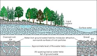
GROUNDWATER - Groundwater is any water that lies in aquifers beneath the land surface. While some of the water that falls as precipitation is channeled into streams or lakes, and some is used by plants or evaporates back into the atmosphere, most of it seeps underground. The oceans contain about 97 percent of the Earth's water, but that, of course, isn't drinkable. About 2 percent is frozen at the poles or in glaciers. The remaining 1 percent is groundwater. The rest of our freshwater is found at the surface in streams, lakes, rivers and wetlands. Groundwater may be near the Earth's surface or as deep as 30,000 feet. An area's "water table" is the level beneath the surface where water-saturated soil and rock is found; above the level of the water table is unsaturated soil — even though that soil is damp, it also contains air. When an aquifer is confined beneath an aquitard layer, the pressure on the groundwater can be enough to force the water out of any well that's drilled into that aquifer. Such wells are known as artesian wells.

a diagram showing groundwater
...................................................................................................................................................................
Groundwater
What is Groundwater?
By Becky Oskin 


Few natural resources are as important, or as invisible, as groundwater.
Even though it exists almost everywhere around the world, few people understand what groundwater is, or how critical these vast reservoirs of underground water are to modern life.
"Groundwater is any water that lies in aquifers beneath the land surface," said Steven Phillips, a hydrologist with the U.S. Geological Survey in Sacramento, California.
While some of the water that falls as precipitation is channeled into streams or lakes, and some is used by plants or evaporates back into the atmosphere, most of it seeps underground.
The oceans contain about 97 percent of the Earth's water, but that, of course, isn't drinkable.
About 2 percent is frozen at the poles or in glaciers.
Of the remaining 1 percent, almost all of it — about 96 percent — is groundwater, according to the National Oceanic and Atmospheric Administration (NOAA).
The rest of our freshwater is found at the surface in streams, lakes, rivers and wetlands.
Groundwater may be near the Earth's surface or as deep as 30,000 feet, according to the U.S. Geological Survey (USGS).
An area's "water table" is the level beneath the surface where water-saturated soil and rock is found; above the level of the water table is unsaturated soil — even though that soil is damp, it also contains air.
How groundwater moves
Because it's impossible to see and difficult to measure, there are a number of myths associated with groundwater.
It's widely believed, for example, that groundwater flows like an underground river: Though there are a handful of places with large underground gaps where water can flow rapidly, these are very rare.
Groundwater does move, however, and it usually flows downward through the force of gravity because most natural replenishment takes place in the mountains, Phillips said.
Depending on the density of the rock and soil through which groundwater moves, it can creep along as slowly as a few centimeters in a century, according to Environment Canada.
In other areas, where the rock and soil are looser and more permeable, groundwater can move several feet in a day.
More porous rock, such as limestone, sandstone and gravel, has innumerable small spaces that can hold water.
Some of the world's largest aquifers — vast underground reservoirs of groundwater — are found in regions with these porous bedrocks.
Groundwater can also be found in regions where the bedrock is made of denser material — such as granite or basalt — if that bedrock has been cracked or shattered.
Dense, impermeable material like clay or shale can act as an "aquitard," i.e., a layer of rock or other material that is almost impenetrable to water, Phillips said.
Through water might move through such material, it will do so very slowly (if at all).
When an aquifer is confined beneath an aquitard layer, the pressure on the groundwater can be enough to force the water out of any well that's drilled into that aquifer. Such wells are known as artesian wells.
Groundwater quality
While surface water quality varies due to erosion, runoff, pollution, plant matter, animal waste and other possible contaminants, groundwater quality is generally more stable.
And because it usually moves slowly through rock, groundwater is filtered of many contaminants, including some bacteria and viruses. These factors make groundwater an important drinking water resource.
This does not mean, however, that groundwater can't be contaminated: There are many cases worldwide where important groundwater resources (and drinking water supplies) have been ruined by saltwater intrusion (a particular problem in coastal areas), biological contaminants such as manure or septic tank discharge, and industrial chemicals such as pesticides or petroleum products.
And once groundwater is contaminated, it's notoriously difficult to remediate.
In addition to concerns about groundwater quality, the overall volume of groundwater in aquifers is also a serious environmental issue.
Groundwater is a finite resource, and even large aquifers can be drained of much of their water, especially during droughts, when aquifers aren't recharged by precipitation.
In California's southern San Joaquin Valley, groundwater levels declined more than 150 feet (46 meters) during the state's severe 1976-1977 drought. This scenario has repeated during subsequent droughts. 
"We're seeing substantial loss of storage in the Central Valley aquifer in California," Phillips said. "It's gone from being a lake in the southern San Joaquin Valley to a place where the water table is 500 feet [152 m] below the surface."
Groundwater losses
Excessive pumping of groundwater can result in a lowering of the water table; in severe cases, where pumping demand is high and aquifer recharge is slow, the water table can drop so low that it's below the depth of a well.
When that happens, the well "runs dry" and no water can be removed until the groundwater is recharged — which, in some cases, can take hundreds or thousands of years.
Lowering the water table also decreases the water flow into lakes, rivers and streams.
"Groundwater is an important ecological resource to critters as well as us, and we've already had serious problems in many areas where big sources of water for wildlife — waterfowl in particular — have dried up," Phillips said. 
The importance of preserving groundwater resources is underscored by the number of places that depend on groundwater for drinking water, industrial uses and other needs.
Texas gets almost 60 percent of its water from groundwater; in Florida, groundwater supplies more than 90 percent of the state's fresh water.
California's farming-centric Central Valley accounts for 20 percent of all of nation's groundwater withdrawals, according to the USGS.
But in these states and many others, groundwater resources are threatened by competing interests, from agriculture and mining to private residences with drinking water wells on the property.
For example, the Ogallala Aquifer — a vast, 174,000 square-mile (450,000 square kilometers) groundwater reservoir — lies beneath the Great Plains, stretching from South Dakota to Texas.
The Ogallala supplies almost one-third of America's agricultural groundwater, but by 2010, about 30 percent of the aquifer's groundwater had been tapped.
Parts of the Ogallala Aquifer are now dry, and the water table has declined more than 300 feet in other areas, according to the Texas Water Development Board.
Not only do these groundwater losses have serious implications for agricultural production and the regional economy, they may also have a significant and immediate effect on the more than 1.8 million people who rely on the Ogallala Aquifer for their drinking water.
"Although there is still a lot of groundwater deep down, it gets saltier and saltier the farther you go," Phillips said.

Additional reporting by Marc Lallanilla.
Follow Becky Oskin @beckyoskin. Follow LiveScience @livescience, Facebook & Google+.

Becky Oskin
Contributing Writer
Becky Oskin covers Earth science, climate change and space, as well as general science topics. Becky was a science reporter at Live Science and The Pasadena Star-News; she has freelanced for New Scientist and the American Institute of Physics. She earned a master's degree in geology from Caltech, a bachelor's degree from Washington State University, and a graduate certificate in science writing from the University of California, Santa Cruz.
a diagram showing groundwater