Tuesday, March 23, 2021

EL NINO - How warm Pacific Ocean temps can alter the weather where you live - Often blamed for any and all out-of-the-ordinary weather, El Niño is a naturally occurring climate event and the warm phase of the El Niño-Southern Oscillation (ENSO) during which sea surface temperatures in the eastern and equatorial Pacific Ocean are warmer than average. How much warmer? An increase of 0.5 C or more in average sea surface temperatures lasting 3 months in a row suggests the onset of an El Niño episode. El Niño means "the boy," or "male child," in Spanish and refers to Jesus, the Christ Child. It comes from South American sailors, who in the 1600s, observed the warming conditions off the Peruvian coast at Christmastime and named them after the Christ Child. El Niño conditions are caused by a weakening of the trade winds. Under normal circumstances, the trades drive surface waters towards the west; but when these die down, they allow the warmer waters of the western Pacific to seep eastward toward the Americas. A major El Niño event generally occurs every 3 to 7 years, and lasts for up to several months at a time. If El Niño conditions will appear, these should begin to form sometime in the late summer, between June and August. Once they arrive, conditions typically reach peak strength from December to April then, subside from May to July of the following year. Events are categorized as either neutral, weak, moderate, or strong.

.........................................................................................................................................................................................................................................................................................................................................................................................
......

El Nino

What Is El Nino?

How warm Pacific Ocean temps can alter the weather where you live

By Tiffany Means


Often blamed for any and all out-of-the-ordinary weather, El Niño is a naturally occurring climate event and the warm phase of the El Niño-Southern Oscillation (ENSO) during which sea surface temperatures in the eastern and equatorial Pacific Ocean are warmer than average.

How much warmer? An increase of 0.5 C or more in average sea surface temperatures lasting 3 months in a row suggests the onset of an El Niño episode.

Meaning of the Name

El Niño means "the boy," or "male child," in Spanish and refers to Jesus, the Christ Child.

It comes from South American sailors, who in the 1600s, observed the warming conditions off the Peruvian coast at Christmastime and named them after the Christ Child.

Why El Niño Happens

El Niño conditions are caused by a weakening of the trade winds.

Under normal circumstances, the trades drive surface waters towards the west; but when these die down, they allow the warmer waters of the western Pacific to seep eastward toward the Americas.

Frequency, Length, and Strength of Episodes

A major El Niño event generally occurs every 3 to 7 years, and lasts for up to several months at a time.

If El Niño conditions will appear, these should begin to form sometime in the late summer, between June and August.

Once they arrive, conditions typically reach peak strength from December to April then, subside from May to July of the following year.

Events are categorized as either neutral, weak, moderate, or strong.

The strongest El Niño episodes occurred in 1997-1998 and 2015-2016. To date, the 1990-1995 episode is the longest-lasting on record.

What El Niño Means for Your Weather

We've mentioned that El Niño is an ocean-atmosphere climate event, but how do warmer-than-average waters in the far-off tropical Pacific Ocean affect weather?

Well, these warmer waters warm up the atmosphere above it. This leads to more rising air and convection.

This excess heating intensifies the Hadley circulation, which in turn, disrupts circulation patterns around the globe, including things like the position of the jet stream.

In this way, El Niño triggers a departure from our normal weather and rainfall patterns including:

Wetter-than-normal conditions along coastal Ecuador, northwestern Peru, southern Brazil, central Argentina, and equatorial eastern Africa (during the months of December, January, February); and over the inter-mountainous U.S. and central Chile (June, July, August).

Drier-than-normal conditions over northern South America, Central America, and southern Africa (December, January, February); and over eastern Australia, Indonesia, and the Philippines (June, July, August).

Warmer-than-normal conditions in southeast Asia, southeast Africa, Japan, southern Alaska, and west/central Canada, SE Brazil, and SE Australia (December, January, February); and along South America's west coast, and again SE Brazil (June, July, August).

Cooler-than-normal conditions along the U.S. Gulf coast (December, January, February).

Tiffany Means

Meteorology Expert

Education

B.S., Atmospheric Sciences and Meteorology, University of North Carolina

Introduction

Studied atmospheric sciences and meteorology at the University of North Carolina

Former administrative assistant for the National Oceanic and Atmospheric Administration

Member of the American Meteorological Society

Experience

Tiffany Means is a former writer for ThoughtCo who contributed articles about weather for five years. She has interned with the domestic and international weather departments at CNN, written monthly climate reports for NOAA’s National Centers for Environmental Prediction, and participated in a number of science outreach events, including the Science Olympiad Competition. Means has personally experienced such weather greats as the Blizzard of 1993 and the floods of Hurricane Francis (2004) and Ivan (2004).

Education

Bachelor's degree in atmospheric sciences and meteorology from the University of North Carolina at Asheville

ThoughtCo and Dotdash

ThoughtCo is a premier reference site focusing on expert-created education content. We are one of the top-10 information sites in the world as rated by comScore, a leading Internet measurement company. Every month, more than 13 million readers seek answers to their questions on ThoughtCo.

For more than 20 years, Dotdash brands have been helping people find answers, solve problems, and get inspired. We are one of the top-20 largest content publishers on the Internet according to comScore, and reach more than 30% of the U.S. population monthly. Our brands collectively have won more than 20 industry awards in the last year alone, and recently Dotdash was named Publisher of the Year by Digiday, a leading industry publication.https://www.thoughtco.com/what-is-el-nino-3444119


WEATHERING AND EROSION - Rock that is close to the land surface is subject to physical and chemical modification by a number of different weathering processes. These processes generally start with water percolating down into joints formed by stress release as the rock comes close to the surface, and are most intense at the surface and in the soil profile. Weathering is the breakdown and alteration of bedrock by mechanical and chemical processes that create a regolith (layer of loose material), which is then available for transport away from the site. Physical weathering are processes that break the solid rock into pieces and may separate the different minerals without involving any chemical reactions. Water entering cracks in rock expands upon freezing, forcing the cracks to widen; this process is also known as frost shattering and it is extremely effective in areas that regularly fluctuate around 0 degree Celsius, such as high mountains in temperate climates and in polar regions. Seawater or other water containing dissolved salts may also penetrate into cracks, especially in coastal areas. Upon evaporation of the water, salt crystals form and their growth generates localised, but significant, forces that can further open cracks in the rock. Changes in temperature probably play a role in the physical breakdown of rock. Rapid changes in temperature occur in some desert areas where the temperature can fluctuate by several tens of degrees Celsius between day and night.

................................................................................................................................................................................................................................................................................................................................................................................

Weathering and erosion

By OK


Weathering processes

Rock that is close to the land surface is subject to physical and chemical modification by a number of different weathering processes.

These processes generally start with water percolating down into joints formed by stress release as the rock comes close to the surface, and are most intense at the surface and in the soil profile.

Weathering is the breakdown and alteration of bedrock by mechanical and chemical processes that create a regolith (layer of loose material), which is then available for transport away from the site.

Physical weathering

These are processes that break the solid rock into pieces and may separate the different minerals without involving any chemical reactions. The most important agents in this process are as follows.

Freeze-thaw action

Water entering cracks in rock expands upon freezing, forcing the cracks to widen; this process is also known as frost shattering and it is extremely effective in areas that regularly fluctuate around 0 degree Celsius, such as high mountains in temperate climates and in polar regions.

Salt growth

Seawater or other water containing dissolved salts may also penetrate into cracks, especially in coastal areas.

Upon evaporation of the water, salt crystals form and their growth generates localised, but significant, forces that can further open cracks in the rock.

Temperature changes

Changes in temperature probably play a role in the physical breakdown of rock.

Rapid changes in temperature occur in some desert areas where the temperature can fluctuate by several tens of degrees Celsius between day and night; if different minerals expand and contract at differentrates, the internal forces created could cause the rock to split.

This process is referred to as exfoliation, as thin layers break off the surface of the rock.

Chemical weathering

These processes involve changes to the minerals that make up a rock. The reactions that can take place are as follows.

Solution

Most rock-forming silicate minerals have very low solubility in pure water at the temperatures at the Earth’s surface and so most rock types are not susceptible to rapid solution.

It is only under conditions of strongly alkaline waters that silica becomes moderately soluble.

Carbonate minerals are moderately soluble, especially if the groundwater (water passing through bedrock close to the surface) is acidic.

Most soluble are evaporite minerals such as halite (sodium chloride) and gypsum, which locally can form an important component of sedimentary bedrock.

Hydrolysis

Hydrolysis reactions depend upon the dissociation of H2O into H+ and OH ions that occurs when there is an acidifying agent present.

Natural acids that are important in promoting hydrolysis include carbonic acid (formed by the solution of carbon dioxide in water) and humic acids, a range of acids formed by the bacterial breakdown of organic matter in soils.

Many silicates undergo hydrolysis reactions, for example the formation of kaolinite (a clay mineral) from orthoclase (a feldspar) by reaction with water.

Oxidation

The most widespread evidence of oxidation is the formation of iron oxides and hydroxides from minerals containing iron.

The distinctive red-orange rust colour of ferric iron oxides may be seen in many rocks exposed at the surface, even though the amount of iron present may be very small.

The products of weathering

Material produced by weathering and erosion of material exposed on continental landmasses is referred to as terrigenous (meaning derived from land).

Weathered material on the surface is an important component of the regolith that occurs on top of the bedrock in most places.

Terrigenous clastic detritus comprises minerals weathered out of bedrock, lithic fragments and new minerals formed by weathering processes.

Rock-forming minerals can be categorised in terms of their stability in the surface environment.

Stable minerals such as quartz are relatively unaffected by chemical weathering processes and physical weathering simply separates the quartz crystals from each other and from other minerals in the rock.

Micas and orthoclase feldspars are relatively resistant to these processes, whereas plagioclase feldspars, amphiboles, pyroxenes and olivines all react very readily under surface conditions and are only rarely carried away from the site of weathering in an unaltered state.

The most important products of the chemical weathering of silicates are clay minerals.

A wide range of clay minerals form as a result of the breakdown of different bedrock minerals under different chemical conditions; the most common are kaolinite, illite, chlorite and montmorillonite.

Oxides of aluminium (bauxite) and iron (mainly haematite) also form under conditions of extreme chemical weathering.

In places where chemical weathering is subdued, lithic fragments may form an important component of the detritus generated by physical processes.

The nature of these fragments will directly reflect the bedrock type and can include any lithology found at the Earth’s surface.

Some lithologies do not last very long as fragments: rocks made of evaporite minerals are readily dissolved and other lithologies are very fragile making them susceptible to break-up.

Detritus composed of basaltic lithic fragments can form around volcanoes and broken up limestone can make up an important clastic component of some shallow marine environments.

Soil development

Soil formation is an important stage in the transformation of bedrock and regolith into detritus available for transport and deposition.

In situ (in place) physical and chemical weathering of bedrock creates a soil that may be further modified by biogenic processes.

The roots of plants penetrating into bedrock can enhance break-up of the underlying rock and the accumulation of vegetation (humus) leads to a change in the chemistry of the surface waters as humic acids form.

Soil profiles become thicker through time as bedrock is broken up and organic matter accumulates, but a soil is also subject to erosion.

Movement under gravity and by the action of flowing water may remove part or all of a soil profile.

These erosion processes may be acute on slopes and important on flatter-lying ground where gullying may occur. The soil becomes disaggregated and contributes detritus to rivers.

In temperate and humid tropical environments most of the sediment carried in rivers is likely to have been part of a soil profile at some stage.

Continental depositional environments are also sites of soil formation, especially the floodplains of rivers. These soils may become buried by overlying layers of sediment and are preserved in the stratigraphic record as fossil soils.

Erosion and transport

Weathering is the in situ breakdown of bedrock and erosion is the removal of regolith material.

Loose material on the land surface may be transported downslope under gravity, it may be washed by water, blown away by wind, scoured by ice or moved by a combination of these processes.

Falls, slides and slumps are responsible for moving vast quantities of material downslope in mountain areas but they do not move detritus very far, only down to the floor of the valleys.

The transport of detritus over greater distances normally involves water, although ice and wind also play an important role in some environments.

Erosion and transport under gravity

On steep slopes in mountainous areas and along cliffs movements downslope under gravity are commonly the first stages in the erosion and transport of weathered material.

Downslope movement

There is a spectrum of processes of movement of material downslope. A landslide is a coherent mass of bedrock that has moved downslope without significantly breaking up in the process.

Many thousands of cubic metres of rock can be translated downhill retaining the internal structure and stratigraphy of the unit.

If the rock breaks up during its movement it is a rock fall, which accumulates as a chaotic mass of material at the base of the slope.

These movements of material under gravity alone may be triggered by an earthquake, by undercutting at the base of the slope, or by other mechanisms, such as water logging of a potentially unstable slope by a heavy rainfall.

Movement downslope may also occur when the regolith is lubricated by water and there is soil creep.

This is a much slower process than falls and slides and may not be perceptible unless a hillside is monitored over a number of years.

A process that may be considered to be intermediate between creep movement and slides is slumping.

Slumps are instantaneous events like slides but the material is plastic due to saturation by water and it deforms during movement downslope.

With sufficient water a slump may break up into a debris flow.

Scree and talus cones

In mountain areas weathered detritus falls as grains, pebbles and boulders down mountainsides to accumulate near the bottom of the slope.

These accumulations of scree are often reworked by water, ice and wind but sometimes remain preserved as talus cones, i.e. concentrations of debris at the base of gullies.

These deposits are characteristically made up of angular to very angular clasts because transport distances are very short, typically only a few hundred metres, so there is little opportunity for the edges of the clasts to become abraded.

A small amount of sorting and stratification may result from percolating water flushing smaller particles down through the pile of sediment, but generally scree deposits are poorly sorted and crudely stratified.

Bedding is therefore difficult to see in talus deposits but where it can be seen the layers are close to the angle of rest of loose aggregate material.

Talus deposits are distinct from alluvial fans because water does not play a role in the transport and deposition.

Erosion and transport by water

Erosion by water on hillsides is initially as a sheet wash, i.e. unconfined surface run-off down a slope following rain.

This overground flow may pick up loose debris from the surface and erode the regolith.

The quantity of water involved and its carrying capacity depends not only on the amount of rainfall but also the characteristics of the surface: water runs faster down a steep slope, vegetation tends to reduce flow and trap debris and a porous substrate results in infiltration of the surface water.

Surface run-off is therefore most effective at carrying detritus during flash-flood events on steep, impermeable slopes in sparsely vegetated arid regions.

Vegetation cover and thicker, permeable soils in temperate and tropical climates tend to reduce the transport capacity of surface run-off.

Sheet wash becomes concentrated into rills and gullies that confine the flow and as these gullies coalesce into channels the headwaters of streams and rivers are established.

Rivers erode into regolith and bedrock as the turbulent flow scours at the floor and margins of the channel, weakening them until pieces fall off into the stream.

Flow over soluble bedrock such as limestone also gradually removes material in solution.

Eroded material may be carried away in the stream flow as bedload, in suspension, or in solution; the confluence of streams forms larger rivers, which may feed alluvial fans, fluvial environments of deposition, lakes or seas.

Erosion and transport by wind

Winds are the result of atmospheric pressure differences that are partly due to global temperature distributions, and also local variations in pressure due to the temperature of water masses that move with ocean currents, heat absorbed by land masses and cold air over high glaciated mountain regions.

A complex and shifting pattern of regions of high pressure (anticyclones) and low pressure (depressions) regions generates winds all over the surface of the Earth.

Winds experienced at the present day range up to storm force winds of 100 km to hurricanes that are twice that velocity.

Winds are capable of picking up loose clay, silt and sand-sized debris from the land surface.

Wind erosion is most effective where the land surface is not bound by plants and hence it is prevalent where vegetation is sparse, in cold regions, such as near the poles and in high mountains, and dry deserts.

Dry floodplains of rivers, sandy beaches and exposed sand banks in rivers in any climate setting may also be susceptible to wind erosion.

Eroded fine material (up to sand grade) can be carried over distances of hundreds or thousands of kilometres by the wind. The size of material carried is related to the strength (velocity) of the air current.

Erosion and transport by ice

Glaciers in temperate mountain regions make a very significant contribution to the erosion and transport of bedrock and regolith.

The rate of erosion is between two and ten times greater in glaciated mountain areas than in comparable unglaciated regions.

In contrast, glaciers and ice sheets in polar regions tend to inhibit the erosion of material because the ice is frozen to the bedrock: movement of the ice in these polar ‘cold-based’ glaciers is mainly by shearing within the ice body.

In temperate (warm based) glaciers, erosion of the bedrock by ice occurs by two processes, abrasion and plucking.

Glacial abrasion occurs by the frictional action of blocks of material embedded in the ice (‘tools’) on the bedrock.

These tools cut grooves, glacial striae, in the bedrock a few millimetres deep and elongate parallel to the direction of ice movement: striae can hence be used to determine the pathways of ice flow long after the ice has melted.

The scouring process creates rock flour, clay and silt-sized debris that is incorporated into the ice.

Glacial plucking is most common where a glacier flows over an obstacle. On the up-flow side of the obstacle abrasion occurs but on the down-flow side the ice dislodges blocks that range from centimetres to metres across.

The blocks plucked by the ice and subsequently incorporated into the glacier are often loosened by subglacial freeze-thaw action.

The landforms created by this combination of glacial abrasion and plucking are called roche moutone'e, apparently because they resemble sheep from a (very) great distance.

Learning Geology is a science website and a community of Earth Scientists that shares geology lessons and host live virtual field tours from all around the world.

With our postings we aim to reach to our fellows with broader public regardless of the boundaries. The postings are done in the great interests of the fellow to learn more and more. The reason for writing is to provide an environment where we can give the best knowledge present just to be shared in the field of Earth and space sciences that we present here. Nobody judge anyone so feel free to feedback and let us know what great ideas you have, be a contributor.  

http://geologylearn.blogspot.com/2015/08/weathering-and-erosion.html


You might also like:


Weathering

CLICK HERE . . . to view . . . 

https://puricare.blogspot.com/2019/11/weathering-mechanical-weathering.html

.............................................................................................................................................................................................................................................................................................

Chemical Weathering

CLICK HERE . . . to view . . . 

https://puricare.blogspot.com/2019/04/chemical-weathering-chemical-weathering.html

...........................................................................................................................................................................

Sunday, March 21, 2021


Surge Tanks

Function and Types of Surge Tanks

By: Syed Ahmad Amin Shah 


Surge Tanks Definition

Surge tank (or surge chamber) is a device introduced within a hydropower water conveyance system having a rather long pressure conduit to absorb the excess pressure rise in case of a sudden valve closure.

The surge tank is located between the almost horizontal or slightly inclined conduit and steeply sloping penstock and is designed as a chamber excavated in the mountain.

There are three main types of surge tanks:

o  Simple Surge Tank

o  Restricted Surge Tank

o  Differential Surge Tank

It also acts as a small storage from which water may be supplied in case of a sudden valve opening of the turbine.

In case of a sudden opening of turbine valve, there are chances of penstock collapse due to a negative pressure generation, if there is no surge tank.

Surge Tank Function

When the valve in a hydroelectric power plant is suddenly completely closed, because of its small inertia the water in the penstock stops almost at once.

The water in the pipeline, with large inertia retards slowly. The difference in flows between pipeline and penstock causes a rise in the water level in the surge tank.

The water level rises above the static level of the reservoir water, producing a counter-pressure so that water in the pipeline flows towards the reservoir and the level of water in the surge tank drops.

In the absence of damping, oscillation would continue indefinitely with the same amplitude.


The flow into the surge tank and water level in the tank at any time during the oscillation depends on the dimension of the pipeline and tank and on the type of valve movement.

The main functions of a surge tank are:

o  It reduces the amplitude of pressure fluctuations by reflecting the incoming pressure waves

o  It improves the regulation characteristic of a hydraulic turbine.

The surge tank dimensions and location are based on the following considerations:

o  The surge tank should be located as close to the power or pumping plant as possible;

o  The surge tank should be of sufficient height to prevent overflow for all conditions of operation;

o  The bottom of surge tank should be low enough that during its operation the tank is drained out and admit air into the turbine penstock or pumping discharge line; and

o  The surge tank must have sufficient cross sectional area to ensure stability.

Types of Surge Tanks

There are different types of surge tanks that are possible to be installed. Some of the most common types of surge tanks which are as follows:


Simple Surge Tank:

A simple surge tank is a shaft connected to pressure tunnel directly or by a short connection of cross-sectional area not less than the area of the head race tunnel.

Restricted Orifice Surge Tank:

A type of surge tanks in which the inlet is throttled to improve damping of oscillations by offering greater resistance and connected to the head race tunnel with or without a connecting/communicating shaft

Differential Surge Tank:

Differential Surge tank is a throttled surge tank with an addition of a riser pipe may be inside the main shaft, connected to main shaft by orifice or ports. The riser may also be arranged on one side of throttled shaft.

In an underground development of hydropower system, tail race surge tanks are usually provided to protect tail race tunnel from water hammer effect due to fluctuation in load.

These are located downstream of turbines which discharge into long tail race tunnels under pressure.

The necessity of tail race surge tank may be eliminated by ensuring free-flow conditions in the tunnel but in case of long tunnels this may become uneconomical than a surge tank.

Water Surface Oscillation

The height of the surge tank is governed by the highest possible water level that can be expected during operation.

Variations in demand initiated by a rapid opening or closure of the valve or turbine are followed with a time lag by the water masses moving in the tunnel.

Upon the rapid and partial closure of the valve following a sudden load decrease, water masses in the penstock are suddenly decelerated, and one part of the continuous supply from the tunnel fills the surge tank.

The water surface in the surge chamber will be raised to above static level.


In case of rapid opening, the flow in the tunnel is smaller than the turbine demand to supply water to the turbine.

The water surface in the chamber will start to drop to below of the steady-state level.

To establish steady-flow conditions, the water surface will again start to rise from the low point, but owing to the inertia of moving water, will again rise over the steady-level.

The cycle is repeated all over again with amplitudes reduced by friction, i.e. the oscillation is damped. The phenomenon described is the water surface oscillation.


https://www.aboutcivil.org/surge-tanks-functions-types.html


https://www.google.com/search?sxsrf=ALeKk01A8jW_wzYoOjdeRjA9Mwf4ReV-zA:1616390997099&source=univ&tbm=isch&q=Surge+Tanks+images&sa=X&ved=2ahUKEwityMzZlcPvAhWUNaYKHUJtCd0QjJkEegQIARAB&biw=2133&bih=1071


Friday, March 19, 2021

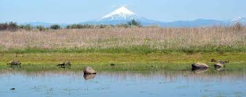
VERNAL POOLS - April showers bring May flowers – and vernal pools, if you live in California or Southern Oregon. Vernal pools are seasonal depressional wetlands that fill up with rainwater during winter and spring, but may be dry for part of the year. They are typically found on the West Coast, especially in California and Southern Oregon, but can also be found in parts of the Northeast and Midwest. Western vernal pools often occur within “vernal pool landscapes” where swales connect vernal pools to each other and to seasonal streams. Vernal pools vary in size from 1 square meter to more than 2 acres. Western vernal pools can connect to other pools and streams that flow seasonally or only after rain. Multiple studies show that California vernal pools fill with water and flow into these channels, sending water downstream during many days of the year. These connections can impact the base flow of downstream waters, altering their physical characteristics. Western vernal pools are also hot spots of biodiversity, with native plant and animal species some of which can only be found in vernal pool habitats. In a study of vernal pools, 17 out of 67 species were only found in one of the surveyed ponds. In turn, these plants and animals provide food and habitat for shorebirds and waterfowl. Vernal pools, like other depressional wetlands, can also help to store and slow floodwaters.

.....................................................................................................................................................................................................................................................................................................................................................................................

Vernal Pools

What Are Vernal Pools and How Do They Help Clean Water

American Rivers


April showers bring May flowers – and vernal pools, if you live in California or Southern Oregon.

Vernal pools are seasonal depressional wetlands that fill up with rainwater during winter and spring, but may be dry for part of the year.

They are typically found on the West Coast, especially in California and Southern Oregon, but can also be found in parts of the Northeast and Midwest.

Western vernal pools often occur within “vernal pool landscapes” where swales connect vernal pools to each other and to seasonal streams.

Vernal pools vary in size from 1 square meter to more than 2 acres.

Why Care About Western Vernal Pools?

Western vernal pools can connect to other pools and streams that flow seasonally or only after rain.

Multiple studies [PDF] show that California vernal pools fill with water and flow into these channels [PDF], sending water downstream during many days of the year.

These connections can impact the base flow of downstream waters, altering their physical characteristics.

Western vernal pools are also hot spots of biodiversity, with native plant and animal species some of which can only be found in vernal pool habitats.

In a study of vernal pools, 17 out of 67 species [PDF] were only found in one of the surveyed ponds.

In turn, these plants and animals provide food and habitat for shorebirds and waterfowl.

Vernal pools, like other depressional wetlands, can also help to store and slow floodwaters.

Are They Protected Under The Clean Water Act?

Right now, it’s unlikely that vernal pools would currently be protected under the Clean Water Act.

The proposed Clean Water Rule acknowledges these connections and sets up a process where similar “other waters” that lie outside of the floodplain can be protected under the Clean Water Act.

These waters collectively with other similar waters must demonstrate a significant connection to downstream waters, meaning that those waters have a more than speculative impact on the chemical, physical, and biological integrity of downstream protected waters.

Although playa lakes aren’t categorically protected right now under the draft rule, the EPA and the Army Corps are looking for input about whether they should be.

Life needs rivers.

It’s not just that rivers make our lives better. We can’t survive without them.

American Rivers works to create a future of clean water and healthy rivers everywhere, for everyone.

American Rivers believes a future of clean water and healthy rivers everywhere, for everyone is essential. Since 1973, we have protected wild rivers, restored damaged rivers and conserved clean water for people and nature. With headquarters in Washington, D.C. and 300,000 supporters, members and volunteers across the country, we are the most trusted and influential river conservation organization in the United States, delivering solutions for a better future.

https://www.americanrivers.org/rivers/discover-your-river/vernal-pools/