:max_bytes(150000):strip_icc():format(webp)/colorado-supercell-2017-807655426-5a823db0d8fdd5003772d0b6.jpg)
..............................................................................................................................................................
The Intertropical Convergence Zone
The Fundamentals of the Intertropical
Convergence Zone
by Matt Rosenberg
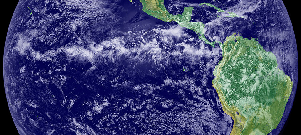
Near the equator, from about 5 degrees north and 5 degrees south, the
northeast trade winds and southeast trade winds converge in a
low-pressure zone known as the Intertropical Convergence Zone (ITCZ).
Solar heating in the region forces air to rise through convection
which results in the accumulation of large thunderstorms and plethora
of precipitation, spreading rain around the Equator year-round; as a
result of this, combined with its central location on the globe, the ITCZ
is a key component of the global air and water circulation system.
The location of the ITCZ changes throughout the year, and how far
from the equator it gets is largely determined by the land or ocean
temperatures underneath these currents of air and moisture — otter oceans yield
less volatile change while varying lands cause varying degrees in the ITCZ's
location.
The Intertropical Convergence Zone has been called the doldrums by
sailors due to the lack of horizontal air movement (the air rises with
convection), and it's also known as the Equatorial Convergence Zone or
Intertropical Front.
The ITCZ Doesn't Have a Dry Season
Weather stations in the equatorial region record precipitation up to
200 days each year, making the equatorial and ITC zones the wettest on the planet.
Additionally, the equatorial region lacks a dry season and is
constantly hot and humid, resulting in large thunderstorms formed from the
convectional flow of air and moisture.
The precipitation in the ITCZ over land has what's known as
a diurnal cycle where clouds form in the late morning and early
afternoon hours and by the hottest time of the day at 3 or 4 p.m.,
convectional thunderstorms form and precipitation begins, but over the
ocean, these clouds typically form overnight to produce early morning
rainstorms.
These storms are generally brief, but they make flying quite
difficult, especially over land where clouds can accumulate at altitudes up to
55,000 feet.
Most commercial airlines avoid the ITCZ while traveling across
continents for this reason, and while the ITCZ over the ocean is usually calmer
during the day and night and only active in the morning, many boats have been
lost at sea from a sudden storm there.
The Location Changes Throughout the Year
While the ITCZ remains near the equator for most of the year, can vary
in as much as 40 to 45 degrees of latitude north or south of the equator based
on the pattern of land and ocean beneath it.
The ITCZ over land ventures farther north or south than the ITCZ over
the oceans, this is due to the variations in land and water temperatures.
The zone mostly stays close to the Equator over water. It varies
throughout the year over land.
In Africa in July and August, for instance, the ITCZ is located just
south of the Sahel desert at about 20 degrees north of the Equator, but the
ITCZ over the Pacific and Atlantic Oceans is usually only 5 to 15 degrees
North; meanwhile, over Asia, the ITCZ can go as far as 30 degrees North.
Matt Rosenberg
Geography Expert
Education
M.A., Geography, California State University
- Northridge
B.A., Geography, University of California -
Davis
Introduction
Award-winning professional geographer
Author of two books on geography
Experience
Matt Rosenberg is a former writer for
ThoughtCo. He covered geography for ThoughtCo and About.com for over 20 years.
He was an adjunct professor of geography at California State University,
Sacramento, a city planning and GIS intern for local government, and is a
former newspaper columnist.
Rosenberg has been featured on PBS and NPR,
and he has conducted many interviews about geographical topics for television,
radio, and newspapers. He was director of emergency services for the American
Red Cross and served on more than two dozen major disaster relief operations
around the United States. He has traveled widely across North America and has
visited or studied in Europe, Asia, Africa, and the Middle East. He is a member
of the Association of American Geographers and the National
Council for Geographic Education.
Education
Matt Rosenberg holds a bachelor's degree
in geography from the University of California, Davis and a master's
degree in geography from California State University, Northridge.
Publications and Awards
"The Handy Geography Answer Book" (Barnes & Noble,
2004)
"The Geography Bee Complete Preparation Handbook"
(Three Rivers Press, 2002)
Excellence in Media Award, National Council
for Geographic Education, October 2006
ThoughtCo and Dotdash
ThoughtCo is
a premier reference site focusing on expert-created education content. We are
one of the top-10 information sites in the world as rated by comScore, a
leading Internet measurement company. Every month, more than 13 million readers
seek answers to their questions on ThoughtCo.
For more than 20 years, Dotdash brands
have been helping people find answers, solve problems, and get inspired. We are
one of the top-20 largest content publishers on the Internet according to
comScore, and reach more than 30% of the U.S. population monthly. Our brands
collectively have won more than 20 industry awards in the last year alone, and
recently Dotdash was named Publisher of the Year by Digiday, a leading industry
publication.
:max_bytes(150000):strip_icc():format(webp)/colorado-supercell-2017-807655426-5a823db0d8fdd5003772d0b6.jpg)


No comments:
Post a Comment