...................................................................................................
Tracking
A Plane
The disappearance of Malaysia Airlines flight MH370
has raised the disturbing question of how a modern aircraft packed with
communications equipment can apparently vanish without trace.
Evidence has emerged to suggest that the Boeing
777-200ER aircraft flew on for hours after being reported missing.
The plane, with 239 people on board, disappeared from
air traffic control screens at approximately 01:20 local time on Saturday 8
March - just an hour after leaving Kuala Lumpur bound for Beijing.
The investigation is now focusing on the actions of
the air crew, as officials believe that the plane was deliberately diverted,
with key communications systems switched off.
So, how do you track a plane and what do we know about
the movements of flight MH370?
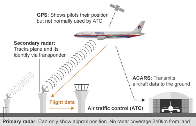
Air traffic control - standard international
practice is to monitor airspace using two radar systems: primary and secondary.
Primary radar -based on the earliest form of
radar developed in the 1930s, detects and measures the approximate position of
aircraft using reflected radio signals. It does this whether or not the subject
wants to be tracked.
Secondary radar, which relies on targets being
equipped with a transponder, also requests additional information from the
aircraft - such as its identity and altitude.
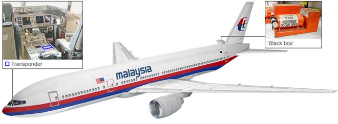
All commercial aircraft are equipped with transponders
(an abbreviation of "transmitter responder"), which automatically
transmit a unique four-digit code when they receive a radio signal sent by
radar.
The code gives the plane's identity and radar stations
go on to establish speed and direction by monitoring successive transmissions.
This flight data is then relayed to air traffic controllers.
However, once an aircraft is more than 240km (150
miles) out to sea, radar coverage fades and air crew keep in touch with air
traffic control and other aircraft using high-frequency radio.
How did
flight MH370 vanish?
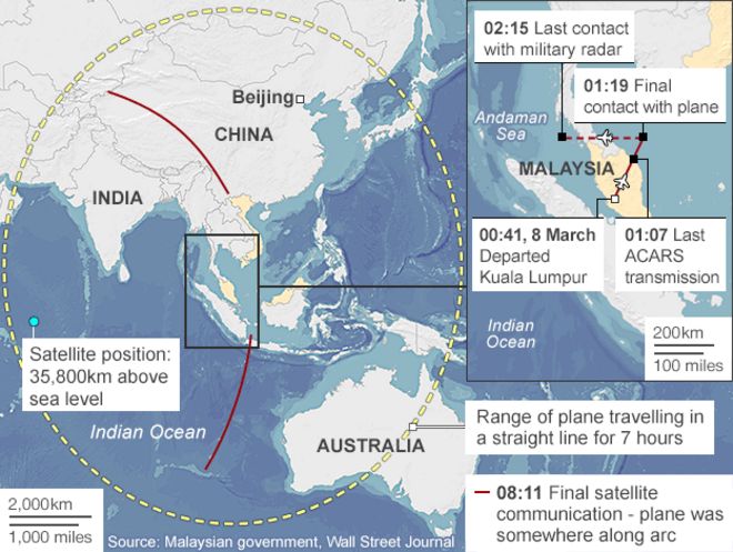
The Boeing 777 disappeared from air traffic control
screens when its transponder signal stopped. The last definitive sighting on
civilian radar showed the aircraft flying north east across the Gulf of
Thailand.
The final radio message received by air traffic
control - "Alright, goodnight" - suggested everything was normal on
board.
Military radar shows that the plane then turned and
headed west across Malaysia towards the Andaman Sea.
On 15 March, satellite data emerged to
suggest the plane could be somewhere on an arc stretching either north up to to
central Asia, or south, to the Indian Ocean and Australia.
Can't planes
be tracked with GPS?
Yes, but while GPS (Global Positioning System) is a
staple of modern life, the world's air traffic control network is still
almost entirely radar-based.
Aircraft use GPS to show pilots their position on a
map, but this data is not usually shared with air traffic control.
Some of the most modern aircraft are able to
"uplink" GPS data to satellite tracking services, but handling large
volumes of flight data is expensive and such systems are usually only used in
remote areas with no radar coverage.
The satellite data which suggests flight MH370 flew on
for several hours are basic 'pings' sent by the plane, and so far only help to
identify two very approximate flight corridors north and south.
Over the next decade, a new system called ADS-B
(Automatic Dependent Surveillance Broadcast) is expected to replace radar
as the primary surveillance method for air traffic control
ADS-B will see aircraft work out their position using
GPS and then relay data to the ground and other planes.
But, as with existing secondary radar, ADS-B coverage
does not extend over the oceans.
ADS-B is already used by flight-tracking websites, but
the Malaysian aircraft disappeared from these at the same time it vanished from
air traffic control screens.
Could other
data systems provide clues?
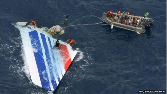
When Air France flight 447 crashed into the mid Atlantic in 2009, its onboard data system - Aircraft Communications Addressing and
Reporting System (ACARS) - gave investigators an early insight into what
had gone wrong.
ACARS is a service that allows computers aboard the
plane to "talk" to computers on the ground, relaying in-flight
information about the health of its systems.
Messages are transmitted either by radio or digital
signals via satellites, and can cover anything from the status of the plane's
engines to a faulty toilet.
This provides ground crews with vital diagnostic
information, allowing maintenance to be carried out more quickly.
In the Air France case, ACARS highlighted faulty speed
readings, which caused the air crew to become disorientated.
The final message from the ACARS onboard the Malaysian
plane came at 01:07 and investigators believe the system was then deliberately
shut down.
Turning off ACARS is no easy feat, requiring a person
with technical knowledge to climb down through a trapdoor into the plane's hull
to remove circuit breakers.
What about
the 'black boxes'?
The mystery of flight MH370 may only ever be
solved when the aircraft's "black box" flight recorders are
recovered.
However, retrieving them from the sea is not easy. In
the case of Air France flight 447, it took nearly two years.
If under water, the boxes emit ultrasonic signals -
but these signals have a limited range, and search crews may not detect them
unless close to the crash site.
Black boxes - described by aviation reporter Stephen Trimble
in The Guardian as "one of the most
galling anachronisms of modern aviation technology" - are not currently equipped with any form of GPS
location transmitter.


.jpg)


No comments:
Post a Comment